製品の説明:
Molas 3Dは、高度な三次元スキャンDoppler風速測定ライダーです。このデバイスは、パルスレーザーコヒーレントドップラー周波数シフトの原理に基づいて動作し、風のパラメータの正確な検出と分析を可能にします。
このシステムは、P-Pl、RHl、DBS、プログラムスキャンなど、複数のスキャンモードをサポートしています。このような汎用性により、さまざまな特定の風速測定要件に適応できます。
Molas 3Dは、幅広いカスタマイズされたアプリケーションに適しています。これらには、洋上風力資源評価、複雑な地形での研究、風力タービンの後流の検出、空港のグライドパスに沿ったウィンドシアー警告が含まれます。
さらに、都市気象観測や高高度乱流の検出にも使用されており、多様な気象および環境モニタリングシナリオにとって貴重なツールとなっています。
特徴:
豊富な測定情報
当社のシステムは、最大300のカスタマイズ可能な距離層にわたる洗練された機能により、詳細な3D風場測定を提供します。これにより、特定の要件に合わせて包括的なデータ収集が可能になります。
広い検出範囲
最大10キロメートルの広範囲な視線検出範囲を提供し、特に高度600メートル以内で効果的です。この広範囲なカバレッジにより、広大なエリアでの信頼性の高いモニタリングが保証されます。
高精度なパフォーマンス
このデバイスは、0.005°のポインティング精度を誇ります。さらに、視線方向の風速は毎秒0.1メートルの精度で測定され、正確な環境分析を可能にします。
多用途なスキャン方法
PPl、RHl、DBS、およびプログラム可能な任意のスキャン方法など、複数のスキャンオプションが統合されています。この汎用性により、ユーザーは特定のアプリケーションに最適なスキャンアプローチを選択できます。
柔軟な展開
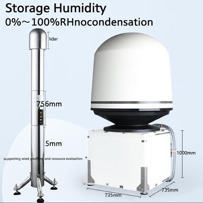
小型軽量に設計されており、さまざまな場所に簡単に輸送して迅速に展開できます。その柔軟性は、迅速な移行と簡単な構築をサポートします。
全天候型耐久性
過酷な屋外条件に耐えるように構築されており、LPz0ゾーンでの生存性を備え、雷保護も含まれています。極端な環境でも信頼性が高く、継続的な運用を保証します。
安全で安全な使用
GPS位置報告とジオフェンシング機能を備えており、システムの安全性と運用管理を保証します。情報漏洩のリスクを防ぐために、データ暗号化が実装されています。
複数の構成オプション
ユーザーは、4つの距離分解能設定と5つの累積時間から選択できるため、多様な測定ニーズに対応するカスタマイズされた構成が可能です。
技術的パラメータ:
| 最大取得距離 |
15 km |
| データ保存時間 |
5〜18か月 |
| ポインティング精度 |
±0.005° |
| 距離分解能 |
15 m / 30 m / 75 m / 120 m |
| スキャン方法 |
PPI、RHI、DBS、およびプログラムスキャン |
| 累積時間 |
0.2〜10秒(オプション) |
| 垂直範囲 |
-10°〜190° |
| 視線風速範囲 |
-75〜+75 m/s |
| データ出力 |
Profibus DP / Modbus TCP / CAN(オプション) |
| 視線検出距離 |
10 km |
アプリケーション:
風力資源評価には、広範囲にわたる風場情報の測定が含まれており、これにより、サイト選定に関連するリスクを軽減できます。この包括的な評価は、風力エネルギープロジェクトに最適な場所を特定するために不可欠です。
長距離の出力曲線測定と後流渦解析は、風力エネルギー利用の最適化において重要な役割を果たします。これらの要因を調べることにより、個々の風力エネルギーユニットの効率を向上させ、全体的な出力を最大化することが可能です。
早期検出および警告システムは、ウィンドシアーやマイクロバーストなどの危険な気象現象を特定するために不可欠です。これらのシステムは、タイムリーなアラートを提供し、潜在的な危険を軽減することにより、安全性を高めます。
空港でのフライト分離を最適化するには、後流渦の測定が重要です。これらの渦の挙動を理解することにより、航空交通をより効果的に管理し、空港運営の安全性と効率を確保できます。
詳細な風場情報を提供することで、境界層内の風の状態を理解するのに役立ちます。このデータは、気象研究や環境モニタリングなど、さまざまなアプリケーションに不可欠です。
地表付近数キロメートル以内の正確で高解像度の時空間風プロファイル情報は、低高度での観測ギャップを埋めます。この強化されたデータ品質は、より良い天気予報と環境評価をサポートします。
プルーム分散に関するリアルタイムの三次元情報は、排出源を効果的に追跡するために使用されます。この機能は、汚染物質を特定および監視することにより、環境保護に役立ちます。
さらに、鉱業における粉塵排出制御の最適化は不可欠です。改善されたモニタリングと管理戦略は、環境への影響を軽減し、持続可能な採掘慣行を促進するのに役立ちます。

 メッセージは20〜3,000文字にする必要があります。